FRESH WATER
FRESHWATER:Naturally occurring water that lacks the salt content found in seawater.
- Lakes
- Rivers
- Ponds
- Streams
- Underground aquifers
FRESHWATER SOURCES

The water cycle is a cycle of processes by which water circulates between the earth's oceans, atmosphere, and land.
When water evaporates from the oceans it moves over land and deposits as precipitation:
- Rain
- Snow
- Fog/Dew
Rain water collects in small streams, this flow is always from higher elevations to lower elevations.
Snow also collect in large glaciers which melt throughout the spring/summer.
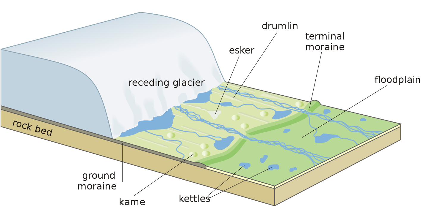
GLACIERS
GLACIERS :Large moving body of ice, glaciers can be many meters or even kilometres thick, and stores vast amounts of freshwater.
- Glaciers that cover vast areas of land are called continental glaciers or icecaps.
- The valley glaciers collect huge or small pieces of rocks, which drag on the surface and determine the form of the land.
|
THE MOVEMENT OF GLACIERS DEPENDS ON THE CLIMATE.
|
|
WHAT IS A WATER SHED?
WATERSHED:
An area of land that drains into one main lake or river.
An area of land that drains into one main lake or river.
- A watershed can contain many smaller rivers and lakes.
- Think of a watershed draining into a river being the same as a funnel that collects water and drains it into a pipe
CONTINENTAL DIVIDE:
The highest point of land on a continent; rivers flow into different oceans depending on which side of the divide they begin.
The highest point of land on a continent; rivers flow into different oceans depending on which side of the divide they begin.
- In Canada the continental divide is the Rocky Mountains.
- The red line on the map divides North America into East and West.
- If water rains west of the divide it will end up flowing into the Pacific Ocean
- If water rains east of the divide it will end up flowing into the Atlantic Ocean
- There are other divides in North America that contribute to the direction water flows
CONTINENTAL DRAINAGE SYSTEMS
- The same forces that shape the ocean basins also build the continental divides.
- At the edge of the continent, two plates meet and push against each other, which cause wrinkles in the continent’s surface to push upward and form mountain ranges.
- Plate tectonics have formed many continental divides.
LIFE OF A RIVER
- Most streams originate in higher elevations such as mountains or high grounds
- Streams steadily increase in volume of flow as they move from mountains to hills
- As streams flow into lower areas, smaller streams begin to combine to form rivers
- Over time rivers slowly begin to twist and turn, this erodes the nearby river banks forming valleys (river is meandering)
- As river waters begin to slow the farther it travels from its source it deposits rocks and minerals into the riverbed
- River eventually forms collects into a lake, or flows into the ocean
RIVER AND STREAM CHARACTERISTICS
IDENTIFYING THE CHARACTERISTICS OF A STREAM OR RIVER IS USEFUL BECAUSE IT HELPS:
- Scientists understand types of organisms living in the waters.
- Scientists hypothesize the impact of human activities on these waters.
- Engineers use stream characteristics to understand how to build bridges and dams.
STREAM ZONES
Erosion Zone (aka Headwaters)
- Fast moving water
- Large sediments enter the water
- Water moving at a slower pace
- sediment is moved along river
- Water moves very slowly
- Sediment is deposited and collected at the bottom of the river
DESCRIBING STREAM CHARACTERISTICS
RESEARCHERS ORGANIZE A RIVER OR STREAMS CHARACTERISTICS WITH A PROFILE.
STREAM CHARACTERISTICS :Characteristics used to describe a stream or river; these include:
THE CHARACTERISTICS OF A STREAM’S SHAPE
THE CHARACTERISTICS OF A STREAM’S SHAPE
- Speed of flow (how fast is the river flowing)
- fast, moderate, slow, crawling
- fast, moderate, slow, crawling
- Quantity of water (amount of water flowing)
- vast (Amazon River), large (North Sask. River), moderate (Bow River),
small (Elbow River), trickle (mountain brook)
- vast (Amazon River), large (North Sask. River), moderate (Bow River),
- Stream shape (does it flow straight or does it curve back and forth)
- straight, sinuous, meandering
- straight, sinuous, meandering
- Stream slope (affects speed of water flow)
- steep, moderate, gentle
- steep, moderate, gentle
- Riverbed shape (how does the bottom of the river look)
- V shaped, U shaped, flat, shallow
- V shaped, U shaped, flat, shallow
- Stream width (how wide is the river)
- wide, intermediate, narrow
- wide, intermediate, narrow
- Stream bank (tall steep cliffs - not much erosion, valleys eroded over time, deltas form via deposition)
- cliffs, steep, deep, plateau, sloping, valleys, broad valleys, sand bars
- cliffs, steep, deep, plateau, sloping, valleys, broad valleys, sand bars
- Stream sediment size (how large are the rocks being pushed by the river)
- large (dime sized), intermediate (small pebble sized), small (grain of sand), fine (grain of flour)
- large (dime sized), intermediate (small pebble sized), small (grain of sand), fine (grain of flour)
- Stream sediment amount, also known as turbidity (more sediment creates murky water)
- large amounts (Mekong Delta), moderate (North Sask. River), small amounts (Bow River)
- large amounts (Mekong Delta), moderate (North Sask. River), small amounts (Bow River)
